Finstock
Born here:
Augustine Cross, Eden Cross, Charlotte Cross, Zachariah Cross, Barnett Cross, Noah Cross, Dorcas CrossFinstock history:
In 1135 the village of Finstock was referred to as Fynstoke. In this period, the village formed part of the manor and parish of Charlbury. Roman coins and Romano-British potsherds have been found in the village and it is thought that there was certainly a settlement of some kind here at the time of the Domesday survey of 1086 when it formed part of the 'hundred of Banbury' belonging to the Bishop of Lincoln.
Finstock, together with its neighbours Charlbury, Fawler and Leafield, lay in a clearing of Wychwood Forest that used to stretch from Woodstock to Burford. Much of the forest land was cleared for growing arable crops and during the Middle Ages barley was the main crop in Finstock. Other land was used for sheep grazing and many of the people of Finstock were involved in the woolen industry - the carding being done by men and boys and the spinning (textiles) by women.
In the early 1500s the manor of Charlbury and its land, including Finstock, was owned by Sir Thomas White, a London tailor who founded St John's College, Oxford in 1555. The manor was then included in the college's endowment. As the college lands were owned by an absentee landlord, the land was leased to many people. The college then resumed direct control until 1857, when the lordship of the manor passed to Francis Spencer, 2nd Lord Churchill of Wychwood, the owner of Cornbury Park. It still remains in the possession of Cornbury Park today although most of the manorial rights have lapsed and much of the village of Finstock is now freehold.
Glove making at the village hall site by the women, and agricultural labouring on nearby land by the men and boys, used to be the principal occupations of the people of Finstock during the earlier part of the 20th century - although now many inhabitants of Finstock commute by car and bus to Witney, Chipping Norton and Oxford.
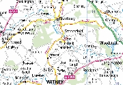
Finstock is now a separate civil and ecclesiastical parish, its population mostly living along the sides of a large triangle formed by the main Witney-Charlbury road (west to north), School Road (east) and Finstock High Street (south). Much in-filling with new buildings has further completed the triangle and four new estates were built during the 20th century. The farming now is mainly arable - barley, wheat and oilseed rape, although some mixed farming is still found.1
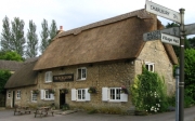
A famous local building is the Plough Inn, situated in The Bottom, was built in 1772. The building was originally a house of modest proportions with a two-room plan and central through passage, probably built for a husbandman (small farmer), but by 1780 was being used as an ale-house.2

